 Filter: Categories of Wisconsin Historical Images
Filter: FORMAT_DIMENSIONS of 47 x 39 cm.
Filter: Categories of Wisconsin Historical Images
Filter: FORMAT_DIMENSIONS of 47 x 39 cm.
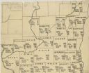
| Date: | 1922 |
|---|---|
| Description: | A hand-sketched map representing 1850 data of southern and eastern Wisconsin displaying the demographical breakouts for the counties in those areas, showin... |
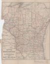
| Date: | 1885 |
|---|---|
| Description: | This map shows current and projected railroad lines. County boundaries in the state of Wisconsin are outlined in red. Included are portions of Iowa, Illino... |
If you didn't find the material you searched for, our Library Reference Staff can help.
Call our reference desk at 608-264-6535 or email us at: